|
||||||||||
|
|||||||||||||
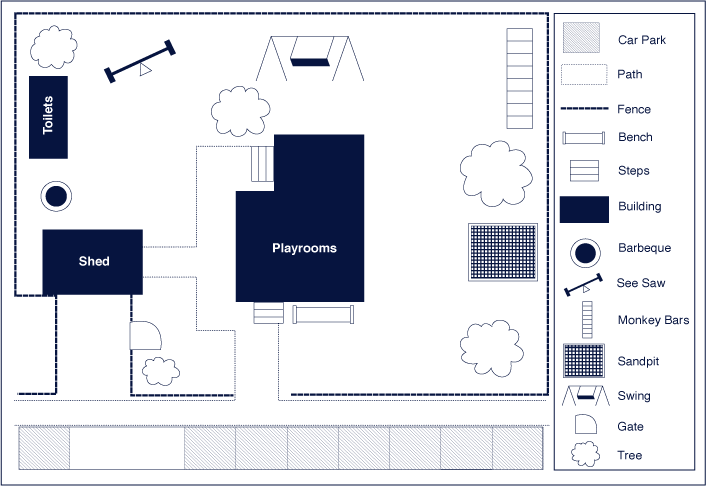
| Questions/instructions:
|
|||||||||||||
| %
responses 2003 ('99) |
|||||||||||||
| y4
|
y8 |
||||||||||||
| 1. How many buildings are there? | 3
|
88
(87) |
97
(97) |
||||||||||
| 2.
When the two teachers have parked their cars, how many parks are left? |
6
|
32
(62) |
58
(77) |
||||||||||
5
|
7
(5) |
9
(3) |
|||||||||||
3.
If someone was in the sandpit, what could they see?
|
swings
|
49
(61) |
62
(71) |
||||||||||
fence
|
55
(66) |
69
(76) |
|||||||||||
tree
|
81
(91) |
95
(96) |
|||||||||||
| 4.
Use the red pen to mark in, on the map, the quickest
way from the toilets to the bench without going inside. |
correct
route |
51
(65) |
86
(87) |
||||||||||
| 5.
More gates need to be put in to keep the children from going onto the
road. Use the red pen to mark in where the gates should
be put. |
front
gate |
28
(31) |
39
(36) |
||||||||||
front
gate and elsewhere |
42
(44) |
49
(52) |
|||||||||||
Total
score: |
8
|
6
(20) |
30
(41) |
||||||||||
6–7
|
28
(39) |
40
(43) |
|||||||||||
4–5
|
39
(26) |
26
(12) |
|||||||||||
2–3
|
24
(14) |
4
(3) |
|||||||||||
0–1
|
3
(1) |
0
(1) |
|||||||||||
| Commentary: There were declines in performance for both year 4 and 8 students between 1999 and 2003, larger for year 4 than year 8. Both year 4 and year 8 students in 2003 had more difficulty when required to use subtraction to answer a question (Q2) or, for year 4 students, to identify features visible from a given position (Q3). Overall, year 8 students interpreted the map more correctly than year 4 students (70% cf 34% achieved a total score of six or more in 2003). |
|||||||||||||