|
||||||
|
|||||||||||
| Questions
/ instructions: Students were presented with a map of the world, with four countries deleted (New Zealand, Japan, Samoa, and the Cook Islands). These countries were available at the bottom of the map. Students were asked to drag these countries to what they believed were the corrrect locations. The computer recorded where the students left each country, on an East-West scale from 0 to 800 and a North-South scale from 0 to 600 (effectively actually 70 to 470). The index point for each country was the centre of the rectangle in which it was displayed. |
|||||||||||
| %
responses |
|||||||||||
| GEd |
MI |
||||||||||
 |
New Zealand: | ||||||||||
within
500km E-W and N-S |
11 | 7 |
|||||||||
within
500km in one direction and 500-1000 km out in the other |
24 | 11 | |||||||||
500-1000
km out in both directions |
12 | 7 | |||||||||
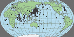 |
Japan: | ||||||||||
within
500km E-W and N-S |
18 | 14 | |||||||||
within
500km in one direction and 500-1000 km out in the other |
11 | 4 | |||||||||
500-1000
km out in both directions |
4 | 11 | |||||||||
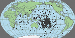 |
Samoa: | ||||||||||
within
500km E-W and N-S |
9 | 0 | |||||||||
within
500km in one direction and 500-1000 km out in the other |
10 | 0 | |||||||||
500-1000
km out in both directions |
4 | 4 | |||||||||
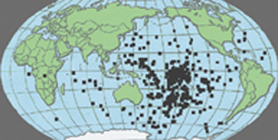 |
Cook Islands: | ||||||||||
within
500km E-W and N-S |
3 | 4 | |||||||||
within
500km in one direction and 500-1000 km out in the other |
5 | 3 | |||||||||
500-1000
km out in both directions |
3 | 4 | |||||||||
Total
score: |
8–12
|
4 | 0 | ||||||||
5–7
|
15 | 14 | |||||||||
3–4
|
23 | 7 | |||||||||
1–2
|
28 | 22 | |||||||||
0
|
30 | 57 | |||||||||
| Commentary: The results achieved by Mäori students in general education (GEd) settings and students in Mäori immersion (MI) settings were not statistically significantly different. |
|||||||||||
| |
||