|
||||||||||||||||
|
||||||||||||||||
%
responses 2009 ('05) |
||||||||||||||||
y4 |
y8 |
|||||||||||||||
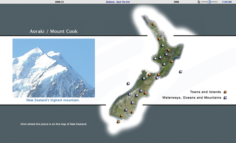
| Correctly located: | Aoraki/ Mount Cook – | New Zealand’s highest mountain | 27 (30) | 46 (51) | ||||||||||||
| Waikato River – | New Zealand’s longest river | 17 (9) | 47 (33) | |||||||||||||
| Pacific Ocean – | meets one side of New Zealand | 23 (27) | 46 (45) | |||||||||||||
| Cook Strait – | ferry boats travel across this | 23 (36) | 70 (84) | |||||||||||||
| Lake Taupo – | great for fishing and boating | 23 (28) | 57 (74) | |||||||||||||
| Clutha River – | has a large power station at Clyde | 9 (11) | 14 (22) | |||||||||||||
| Stewart Island – | a national park | 38 (53) | 76 (87) | |||||||||||||
| Mount Taranaki – | has also been called Mount Egmont | 7 (11) | 27 (30) | |||||||||||||
| Waitangi – | where an important treaty was signed | 10 (9) | 25 (27) | |||||||||||||
Total
score: |
8–9 |
0 (0) | 5 (6) | |||||||||||||
| 6–7
|
4 (5) | 23 (25) | ||||||||||||||
| 4–5
|
13 (18) | 33 (42) | ||||||||||||||
| 2–3
|
29 (33) | 22 (19) | ||||||||||||||
| 0–1 | 55 (44) | 17
(8) |
||||||||||||||
| Subgroup Analysis [Click on charts to enlarge] : |
Year 4 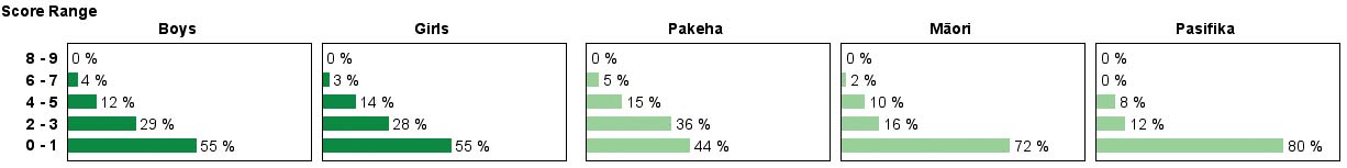 |
||
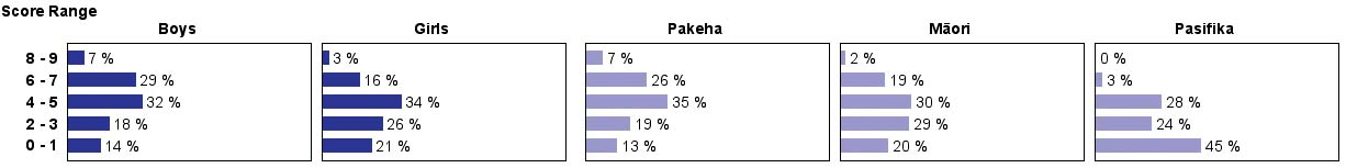
| Commentary: |
On
average, about 20% more year 8 than year 4 students were able to locate
specific places on a New Zealand map. The places located most frequently
were Stewart Island, Cook Strait, Lake Taupo, Aoraki/Mt Cook and the
Pacific Ocean. At year 8, boys performed significantly better than girls.
Year 4 Mäori and Pasifika students and year 8 Pasifika students
scored much lower than their Pakeha counterparts. |