 Approach: Station Approach: Station
|
| Focus:
Reading a map and using
a map scale.
|
 |
236k |
Resources: Map,
ruler. |
|
Questions
/ instructions:
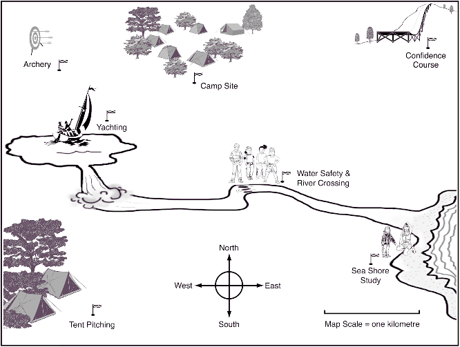
Here is a map of a camp site
and activities. Look at the map scale and the compass to help you answer the questions.
Put
a ring around the letter beside the best answer.
|
|
%
responses |
|
y4
|
y8
|
|
1. About how
far is it from the camp site to the yachting?
a.
1 kilometre
b. 2 kilometres
c. 3 kilometres
d. 5 kilometres
|
a
|
-
|
77
|
|
2. About how far is it from
the camp site to the tent pitching?
a. 1 kilometre
b. 2 kilometres
c. 3 kilometres
d. 5 kilometres
|
c
|
-
|
59
|
|
3. Which distance is the
smallest?
a. between
camp site and seashore study?
b. between camp site and tent pitching?
c. between camp site and water safety?
|
c
|
75
|
93
|
|
4. In which
direction does the river flow from the waterfall to the sea shore?
a. North
b. South
c. East
d. West
|
c
|
76
|
90
|
|
5. Which activity is west
of the camp site?
Write your answer on the line.
|
archery
yachting or tent pitching
|
47
37
|
73
15
|
Commentary:
On the three questions
attempted by both year 4 and year 8 students, about 20 percent more year 8 than
year 4 students were successful. |