|
|
:
Mexico |
|
|
|||||
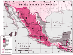
| Focus: Interpreting a map of Mexico and Central America. | |||||
|
|||||
|
|
|||||
|
%
responses
|
|||||
|
y8
|
|||||
|
1. Look at
Mexico City. |
2000–4000m
above sea level
|
57
|
|||
|
capital
city
|
68
|
||||
|
Other
correct facts: 2 or more
|
2
|
||||
|
1
|
17
|
||||
| 2.
If I was to travel from Mexico City to Leon, approximately how far would that
be? There is a ruler here if you want to use it. |
300–330km
300–330 |
28
4 |
|||
| 3.
The map shows that Mexico has several neighbours. Tell me two neighbours of Mexico. |
U.S.A.
|
66
|
|||
|
Honduras
|
26
|
||||
|
Guatemala
|
18
|
||||
|
other
correct
|
2
|
||||
|
Number
correct: 2 or more
|
41
|
||||
|
1
|
30
|
||||
| 4. Show me where the highest area of land is in Mexico. |
identified
correct area
|
70
|
|||
| 5. What city is close to 100 degrees longitude and 25 degrees latitude? |
Monterrey
|
22
|
|||
| Commentary: The year 8 students had mixed success with this task. They struggled with the use of a scale to measure distance, with identifying small countries on the map, and with using longitude and latitude data to locate a city. |
|||||
|
|
||
|
|
||