|
: Eastland Brochure
|
|
|||||
|
Questions
/ instructions: |
|||||
    |
|||||
| % responses | |||||
|
y4
|
y8
|
||||
|
1. What is the purpose of the big map? |
greater
detail of area, activiites, access, geographical features
|
||||
|
clear
with multiple ideas
|
7
|
||||
|
relevant,
not fully developed
|
25
|
||||
|
on
right track but vague
|
47
|
||||
|
other
|
21
|
||||
|
2. What is the purpose of the small map? |
to
show where Eastland region is in North Island
|
|
|||
|
clear
|
29
|
||||
|
partial
|
40
|
||||
|
other
|
31
|
||||
|
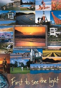
3. Why do you think the brochure has so many photos? |
looks
nice, identifies range of activiites
|
|
|||
|
looks
nice & range of activities
|
15
|
||||
|
looks
nice
|
19
|
||||
|
range
of activities
|
25
|
||||
|
other
|
41
|
||||
|
4. What is the overall message that the brochure is giving about this area? |
good
place to visit for scenery and activities
|
||||
|
captures
message in detail
|
30
|
||||
|
on
right track but rather general or vague
|
52
|
||||
|
other
|
18
|
||||
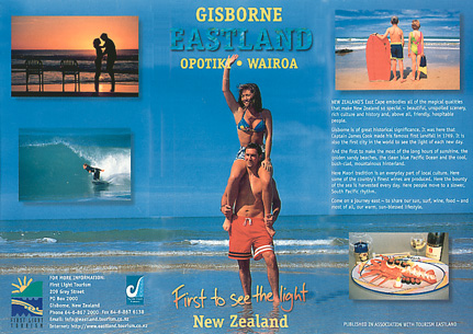
 5.
This logo is on the brochure. Write inside the boxes what the different
parts of the logo might mean. 5.
This logo is on the brochure. Write inside the boxes what the different
parts of the logo might mean. |
Box
A: sun 39 rising sun/setting sun
|
11
|
|||
|
first
to see the light
|
13
|
||||
|
Box
B: mountains/hills
|
46
|
||||
|
sea/water
|
14
|
||||
|
Box
C: sea/water/waves
|
48
|
||||
|
land
hills
|
13
|
||||
|
Box
D: sea/waves & Mäori links (koru)
|
3
|
||||
|
Mäori
links
|
22
|
||||
|
sea/waves
|
42
|
||||
| Commentary: The year 8 students had only moderate success in understanding the approaches used in the brochure and explaining them. The responses to Question 5 indicate that about 40 percent of the students understood little about the choice of logo elements. |
|||||
[ top of the page | Listening and Viewing Report 1998 ]