|
:
Landscapes
|
|
|||||
|
Questions / instructions:
|
|||||
| % responses | |||||
|
y8 |
|||||
|
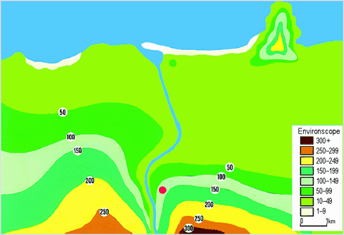
1. I'll point to different parts
of the map, and I want you to tell me what you think they are. |
the sea |
75
|
|||
|
beach |
85 |
||||
|
river |
89 |
||||
|
land |
61 |
||||
|
contour lines showing
the height of the land above sea level. |
23 |
||||
|
2. Can you tell me what this contour
line means? |
Explained
contour lines: quite fully |
35 |
|||
|
partially
|
33 |
||||
|
no
|
32 |
||||
|
3. Here are some labels for names
of parts of the landscape. I want you to put each sticker on a place that you
think would be suitable. |
Placed
labels appropriately: |
||||
|
estuary |
26 |
||||
|
light-house |
55 |
||||
|
penguins |
87 |
||||
|
sand dunes |
86 |
||||
|
dam |
36 |
||||
|
4. What could be 1 really good reason for building the green house here? |
84 |
||||
| 5. What could be 1 problem with building the green house there? |
86 |
||||
| 6. What could be 1 really good reason for building the red house here? |
75 |
||||
| 7. What could be 1 problem with building the red house here? |
59 |
||||
| Commentary: This task required students to identify aspects shown on a relatively simple topographical map, and to interpret these in making decisions about the most appropriate location of a number of features. Quite a high percentage of students were very capable of reading, understanding and interpreting the information provided on the map. |
|||||
| [ top of the page | Social Studies Report 1997 ] | |||||