| Approach: Station |
Level:
Year 4
and year 8 |
|
| Focus:
Interpreting
a map
|
| Resources:
Map, red pen,
blue pen |
 |
1.3KB |
|
|
Questions/instructions:
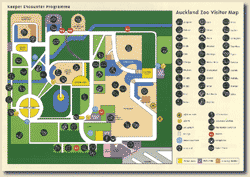
This is a map of Auckland Zoo.
Use this map to help you answer the questions. |
 [click
on map to enlarge]
 |
|
|
%
responses
2003 ('99) |
| y4
|
y8 |
| 1.
Find the entrance to the zoo. Mark it with a red X.
|
88
(87) |
97
(95) |
2.
Start from the entrance. Draw in red the quickest way to get to the tigers.
Mark T for tigers.
|
quickest
way from the entrance to the tigers |
56
(53) |
80
(82) |
tigers
marked with T |
81
(84) |
92
(91) |
3.
Start from the tigers. Draw in blue the quickest way to get to the bats.
Mark B for the bats.
|
quickest
way from the tigers to the bats |
32
(26) |
67
(62) |
bats
marked with B |
85
(86) |
93
(91) |
| 4.
Some parts of the map are coloured purple. What does this mean? |
buildings |
55
(58) |
86
(87) |
| 5.
Find the toilet nearest to the elephants. Circle it in red. |
65
(75) |
93
(93) |
| |
|
|
Total
score:
|
7
|
12
(9) |
50
(47) |
5–6 |
46 (52) |
39
(42) |
3–4
|
30
(29) |
10
(8) |
1–2
|
9
(9) |
1
(3) |
0
|
3
(1) |
0
(0) |
Commentary:
Year 4 and year 8 students achieved very similarly in 1999 and 2003. Students
were particularly strong in most aspects of locating places on a map (Q1
and Q5). |