|
||||||||||||||
|
||||||||||||||
%
responses 2007 ('03) |
||||||||||||||
y4 |
y8 |
|||||||||||||
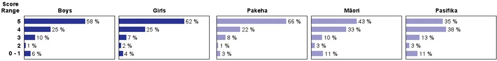
| 1. Which of these streets will the parade travel on first? |
||||||||||||||
| a. Wainui St | ||||||||||||||
| b. Collingwood St | 46 (43) |
79 (75) |
||||||||||||
| c. Dundas St | ||||||||||||||
| 2. The parade will go right past? |
||||||||||||||
| a. Cinema | 64 (71) |
89 (88) |
||||||||||||
| b. Post Office | ||||||||||||||
| c. Trafalgar Centre | ||||||||||||||
| 3. Which of these streets will not be used in the parade? |
||||||||||||||
| a. Trafalgar St | ||||||||||||||
| b. Halifax St | ||||||||||||||
| c. Grove St | 74 (79) |
92 (93) |
||||||||||||
| 4. What is the last street the parade
will use? |
||||||||||||||
| a. Wainui St | 78 (82) |
94 (94) |
||||||||||||
| b. Collingwood St | ||||||||||||||
| c. Dundas St | ||||||||||||||
| 5. Which of these cannot be found
on this map? |
||||||||||||||
| a. where the parade starts | ||||||||||||||
| b. how long the parade will last | 67 (69) |
91 (91) |
||||||||||||
| c. how many streets the parade will use | ||||||||||||||
Total
score: |
5 |
27 (24) |
60 (60) |
|||||||||||
4 |
25 (33) |
26 (27) |
||||||||||||
3 |
18 (21) |
8 (10) |
||||||||||||
2 |
12 (11) |
2 (2) |
||||||||||||
0–1 |
19 (11) |
5 (2) |
||||||||||||
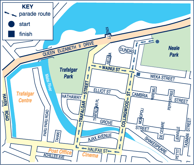
| Subgroup Analysis [Click on charts to enlarge] : |
Year 4 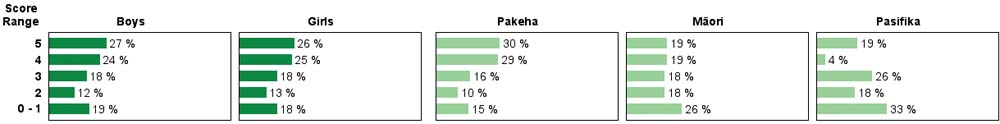 |
||
| Commentary: |
| The ability to read and understand a map shows strong growth between year 4 and year 8. Well over half of the year 8 students got all items correct. Performance was similar in 2003 and 2007. Boys and girls performed similarly. Year 4 Pasifika students had more difficulty with this task than their Pakeha and Mäori counterparts. |