|
||||||||||||
|
|||||||||||||
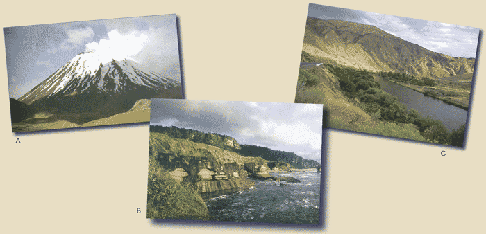
| Questions/instructions: Show pictures. The land around
us changes over time. In this activity, you are going to tell me what
you think has formed the land. Look at each of these pictures carefully. |
|||||||||||||
%
responses |
|||||||||||||
y4 |
y8 |
||||||||||||
| Show picture A. | |||||||||||||
| 1.
This is a volcano. How was this formed or made? |
inside
of earth gets too hot in particular region |
9 |
9 |
||||||||||
magma/lava
(melted rock) escapes and spills over |
17 |
28 |
|||||||||||
flow
of magma/lava tends to create cone shaped hill/mountain |
6 |
11 |
|||||||||||
Earth’s
plates create cracks/weak spots for magma to escape: |
|||||||||||||
detailed |
0 |
3 |
|||||||||||
general
idea |
4 |
12 |
|||||||||||
|
Show picture B. |
|||||||||||||
| 2.
This is a coast line. How was this formed or made? |
sea
action on coast erodes coast |
28 |
56 |
||||||||||
| Show picture C. | |||||||||||||
| 3.
This is a river valley. How was this formed or made? |
river
erodes (cuts into) the land |
7 |
19 |
||||||||||
| occasional
river floods outside channel deposit silt to make fertile valley |
1 |
1 |
|||||||||||
Total
score: |
4–8
|
3 |
7 |
||||||||||
3
|
4 |
14 |
|||||||||||
2
|
10 |
22 |
|||||||||||
1
|
26 |
27 |
|||||||||||
0
|
57 |
30 |
|||||||||||
| Commentary: The level of understanding of the formation of volcanoes and river valleys was low. |
|||||||||||||
| |
||