|
||||||||||
|
||||||||||||
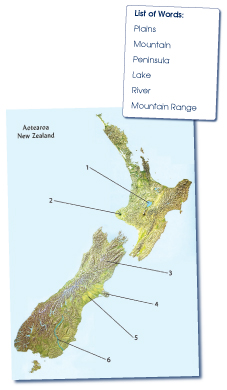 |
Questions/instructions: Put physical relief map and list of words in front of student. This map of New Zealand is called a relief map. It shows the shape of the land and its physical features. I’m going to ask you what is being shown on the map. Choose from this list of words when deciding your answers. I’ll read out the list of words. Read the list of words to the student. |
|||||||||||
| %
responses 2005 (01) |
||||||||||||
| y4 |
y8 |
|||||||||||
| Point with a pen to number 1. | ||||||||||||
| 1. What is being shown here? | lake
|
88
(88) |
98
(97) |
|||||||||
| Point with a pen to number 2. | ||||||||||||
| 2. What is being shown here? | mountain
|
61
(59) |
73
(77) |
|||||||||
| Point with a pen to number 3. | ||||||||||||
| 3. What is being shown here? | mountain
range |
43
(49) |
74
(77) |
|||||||||
| Point with a pen to number 4. | ||||||||||||
| 4. What is being shown here? | peninsula
|
40
(39) |
71
(64) |
|||||||||
| Point with a pen to number 5. | ||||||||||||
| 5. What is being shown here? | plains
|
60
(53) |
76
(76) |
|||||||||
| Point with a pen to number 6. | ||||||||||||
| 6. What is being shown here? | river
|
90
(85) |
98
(97) |
|||||||||
Total
score: |
6
|
21
(19) |
55
(53) |
|||||||||
5
|
5
(5) |
3
(4) |
||||||||||
4
|
33
(34) |
26
(26) |
||||||||||
3
|
24
(22) |
10
(12) |
||||||||||
2
|
13
(14) |
5
(4) |
||||||||||
1
|
3
(5) |
1
(1) |
||||||||||
0
|
1
(1) |
0
(0) |
||||||||||
| Commentary: About 35 percent more year 8 than year 4 students identified all six features correctly. There was no meaningful change, at either year level, between 2001 and 2005. |